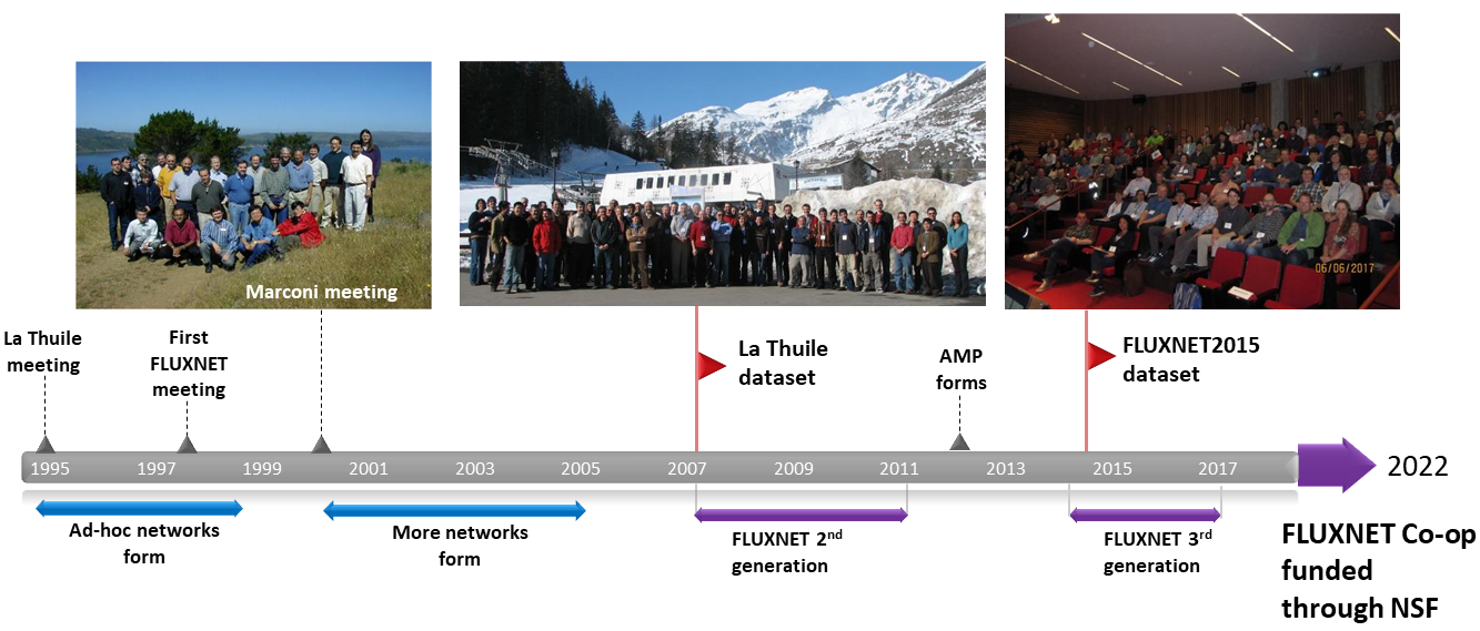
FLUXNET Current status
In 2022, the National Science Foundation awarded an AccelNet proposal, the FLUXNET Coordination Project, to the University of California, Berkeley to support the next generation of FLUXNET activities. These activities include the launching of the FLUXNET Secondment Program, annual workshops, scholar exchange, and creating a community code pipeline. Activities will be overseen by the FLUXNET Community Council. The ultimate goal of the FLUXNET Coordination Project is to support the FLUXNET community in building robust data-sharing and community infrastructure that endures beyond the life of the grant.
FLUXNET 3rd generation
In 2014, the Department of Energy, USA awarded a proposal to University of California, Berkeley and Lawrence Berkeley National Laboratory to revive and expand FLUXNET. With new scientific questions facing the global biogeoscience community, efforts were made to produce datasets that are open and freely and fairly shared among the science community. To create this database, scientists built a data-system that processes raw data and produces value-added data products.
The FLUXNET2015 Database is the result of years of collaboration among the FLUXNET2015 data team to prepare and process data from regional networks around the world. This team included The AmeriFlux Project Management, the European Ecosystem Fluxes Database, and the ICOS Ecosystem Tematic Centre (ICOS-ETC). FLUXNET2015 encompasses 212 flux sites and over 1500 site-years of data from a range of ecosystem types (Pastorello et al, 2019) (Figure 1), and has contributed to a large and growing body of ecosystem research.
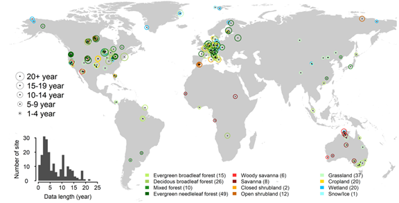
Figure 1. From Pastorello et al, 2019: Map of 206 tower sites included in this paper from the 212 sites in the February 2020 release of the FLUXNET2015 dataset. The size of the circle indicates the length of the data record. The color of the circles represents the ecosystem type based on the International Geosphere–Biosphere Programme (IGBP) definition. When overlapping, locations are offset slightly to improve readability. Numbers in parentheses indicate the number of sites in each IGBP group. The inset shows the distribution of data record lengths.
FLUXNET 2nd generation
The second stage of FLUXNET was supported by the National Science Foundation (NSF), USA, through the Research Coordination Networks program (2007-2011). The large and sustained growth of the network and database also attracted financial and in-kind support from computer scientists at Microsoft and Lawrence Berkeley National Laboratory, USA. Collaboration with computer scientists was critical to develop a new and interactive data system (fluxdata.org), as the size of the database got too large to exchange on floppy drives and excel spreadsheets, and the needs of the scientific community to manipulate these data became too complex. Several institutions supported the development and implementation of the database. These include Max Planck Institute for Biogeochemistry – Germany, University of Tuscia – Italy, Microsoft Research eScience, Berkeley Water Center, University of California – Berkeley, Lawrence Berkeley National Laboratory, University of Virginia, and Oak Ridge National Laboratory.
In 2007, the next-generation integrated flux and meteorological data set—the La Thuile Database—was produced and released (Figure 1c, 1d). This database contained carbon dioxide, water vapor, and energy fluxes and meteorological variables from 252 sites. It represented 965 site-years of data and it possessed 12 sites with a decade of data. Through the auspices of the data system, data were exchanged and shared among the data producers for the production of a variety of synthesis projects on carbon and water exchange and model validation and parameterization studies.
A workshop convened at Asilomar (California, USA) in 2009 brought global flux modelers and the flux community together to address how flux data could improve efforts to model land surface and climate and the carbon cycle better. Ideas from this workshop are being worked into current versions of the land component of Earth system models, such as the NCAR Community Land Model. A product from this workshop was a paper in Ecosystems on how Drought Influences the Accuracy of Simulated Ecosystem Fluxes.
The second phase of FLUXNET support was capped in 2011 with the Berkeley Conference that brought the flux and spectral reflectance (SpecNet) communities together. Novel reports at this meeting included the first efforts to produce empirical maps of fluxes across continents and the globe using a combination of machine learning methods, flux data, and satellite remote sensing.
FLUXNET beginnings
The FLUXNET project started circa 1997 with support from National Aeronautics and Space Administration (NASA), USA to provide ground truth support for the new Earth Observing System (EOS) and the Moderate Resolution Imaging Spectroradiometer (MODIS) carried on the Terra and Aqua satellites. Impetus for the network arose after discussions and results were presented in 1995 at the LaThuile workshop, in the Italian Alps. At this workshop scientists presented their first efforts to measure carbon, water and energy fluxes on a quasi-continuous basis for a year or more. Reports from this workshop were published in 1996 in a special issue of Global Change Biology.
After the workshop, there was enough support from the scientific community to encourage an ad hoc group of flux scientist to propose and develop regional networks in Europe, North America and Asia such as EuroFlux, AmeriFlux and AsiaFlux, and it gave government agencies confidence to fund this work. The role of FLUXNET was to form a global network, uniting these regional networks, and to provide a data portal and database, housed at Oak Ridge National Laboratory, USA. At this stage, the focus of FLUXNET was to develop value-added datasets with standardize variable names and units, with developed gap filling and flux partitioning methods and to produce daily and annually integrated flux budgets.
The first official FLUXNET workshop was held in 1998 in Polson, Montana, USA. At this event, scientists discussed new successes, like the first flux comparisons between biomes, and emerging problems associated with the loss of carbon dioxide at night under tall forests canopies and sloping terrain. Visions for combining flux data and satellite remote sensing, to produce global estimates of gross and net carbon exchange were articulated and discussed, and later published in 1999 in Remote Sensing and Environment.
The next milestone in the history of FLUXNET was the 2000 Marconi workshop (California, USA). Here, a group of 30 scientist met and shared data for the first time and to plan and produce a set of synthesis papers, published in 2002 in Agricultural and Forest Meteorology. In the early stages of FLUXNET, the community was small, it was easy for people to know each another, and the amount of collected flux data (97 site-years) was small (38 sites) and short (1 to 3 site-years), so data files were easily shared by emailing spreadsheets back and forth. Resulting papers reported on gap filling and flux partitioning methods, relationships between carbon and water fluxes and environmental drivers, documents on the uncertainties and corrections to measured fluxes, information on how to measure fluxes at night during stable conditions, and a synthesis on energy balance closure.
Through the mid-2000s the network continued to grow as regional networks were established in Brazil, across Canada, China and in Australia. Additional international workshops were held in Orvieto (2002), Lake Tahoe (2003) and Firenze (2004) to foster international communication and to address the next level of science questions. At this stage, data were ready for one of the first comparisons between fluxes of gross carbon exchange, produced by the MODIS sensor using a light use efficiency model, and flux towers from across the globe.